My Specialized Tricross hybrid has taken me over nearly all bike trails of Northern Virginia
and DC. One of my best is the Rock Creek Park trail in DC. This is about a 30-40 mile round
trip from
.
I started tracing my path on the Every Trail site
using my Google phone and the Every Trail app. The Every Trail site uses Actionscript and renders
the trail in Flash. I thought it would be better to have it using JavaScript because currently
(as of July 2009) Flash has not yet come to iPhones, though Adobe had announced that it was
in the making. So I wrote my own JavaScript by putting together the GoogleMaps API and Jquery.
Here you will see my biking trails overlapped on Google maps.
To reach the eastern end of the Western Maryland Rail Trail, take exit 12, MD 56, from I-70. Turn east and go to Big Pool. The trail parking lot is across the street from the Post Office.
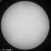
Time-distance helioseismology is a method to study the interior of the Sun by
computing travel time of individual acoustic wavepackets as they travel
through the Sun between two spatially separated locations on its
surface. I have contributed to the theoretical development of this field.
eg. Theoretical Foundations of Time-Distance Helioseismology
Helioseismic tomography
is a form of the tomographic techniques adapted to image
the interior of the Sun from observations of the acoustic oscillations
at the surface. The important adaptation is the computation of travel
time through time-distance helioseismology. I have contributed in the
aspects of its adaptation and improvement.
eg. A Note on Helioseismic Tomography
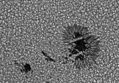
This study involves the dynamics of their progenitors
-- magnetic flux tubes --- from the region of their origin
(200,000 km beneath the solar surface) through a highly turbulent convectively
unstable region. We modeled the flux tube to be a one-dimensional string
with all properties of a magnetic flux tube allowed to move in the three-dimensional
space of the convection zone. We could successfully explain a number of
dynamical and morphological properties of sunspots if the magnetic
field strength of the flux tubes at the region of their origin were of
the order of 100,000 G. This is order of magnitude larger than the
field that would be in energy equipartition with the turbulent motions. A Theoretical Model for Tilts of Bipolar Magnetic Regions